近年取り組んでいる代表的な研究プロジェクトをお示しします。これ以外にも色々な研究にかかわっていますので、興味がある方はお問合せ下さい。
Below are some of the representative research projects we have been working on in recent years. We are also involved in various other research projects, so please contact us if you are interested.
- 波浪うちあげのリアルタイム観測と予測
Real-Time Monitoring and Prediction of Wave Overtopping - 海面動画を用いた海底地形の推定
Estimation of Bathymetry from Sea Surface Videos - 沿岸での波浪水理の解明と予測
Understanding of Nearshore Wave Hydrodynamics - 沿岸災害事例の事後分析
Post-Event Analysis of Coastal Disater - 海岸観測手法の開発
Develpment of Coastal Monitoring Method
波浪うちあげのリアルタイム観測と予測
Real-Time Monitoring and Prediction of Wave Overtopping
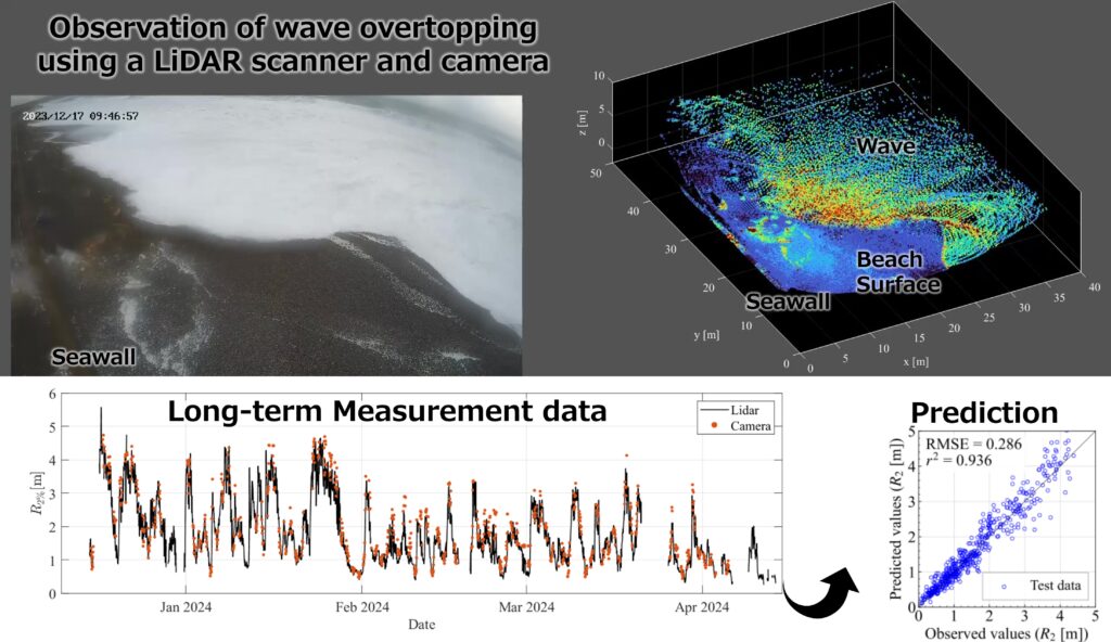
LiDARと呼ばれるレーザー光を用いた測距技術を用いた、波浪うちあげの常時リアルタイム観測技術の開発を行っています。この技術は従来のカメラを用いた観測手法と比べ、夜間や荒天時にも運用可能で、定量的な観測結果を得ることができます。また、本技術によって得られた豊富な観測データをもとに、波浪うちあげ高の予測手法の開発も行っています。こうした技術を確立することで、台風や低気圧来襲時の高潮・高波による沿岸災害時において、迅速な住民避難や事後対応に貢献することが期待されます。
We are developing a real-time, continuous observation technique for wave overtoppping using a laser-based ranging technique called LiDAR. Compared to conventional camera-based observation techniques, this technology can be operated at night and in stormy weather, and quantitative observation results can be obtained. We are also developing a method for predicting runup heights based on the abundant observation data obtained by this technology. The establishment of this technology is expected to contribute to the rapid evacuation of residents and post-event recovery to coastal disasters caused by storm surges and high waves during typhoons and low-pressure systems.
海面動画を用いた海底地形の推定
Estimation of Bathymetry from Sea Surface Videos
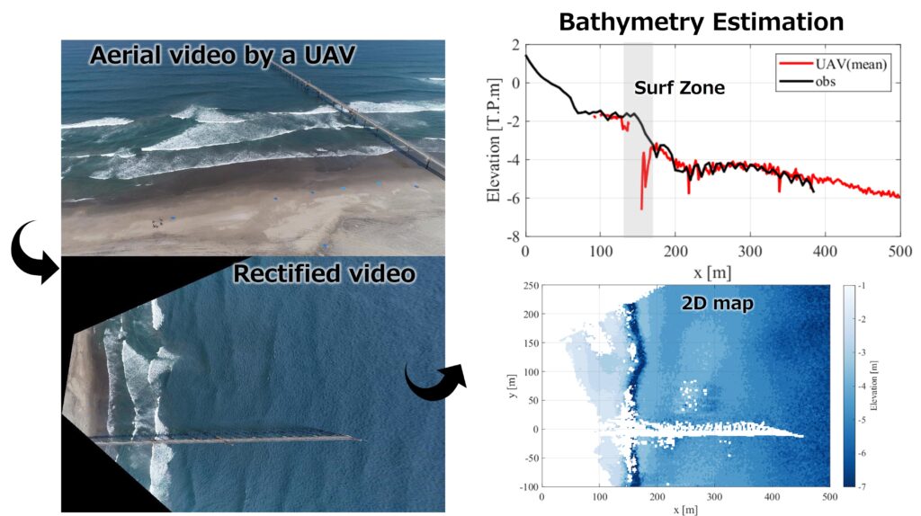
UAV(通称ドローン)や高所に設置した監視カメラから撮影された海面動画をもとにした広域での海底地形の推定手法の構築を行っています。この手法では、海面動画から波の伝播速度と周期を抽出することで波の理論に基づいて水深を推定することができます。浅海部は人や船の立ち入りに危険が伴うため直接の測量が困難な一方、激しい地形変化が生じる領域です。安価かつ広域での海底地形の推定手法を構築することで、より高頻度な海岸地形変化の把握を実現し、ひいては効率的な海岸管理に貢献することが期待されます。
We are developing a method for estimating bathymetry over a wide area based on sea surface videos taken by UAVs (commonly known as drones) and surveillance cameras at high altitudes. This method can estimate water depth based on wave theory by extracting wave propagation speed and period from sea surface videos. Shallow-water areas are difficult to survey directly due to the danger of human and ship entry, but they are also areas where severe topographic changes occur. The development of the inexpensive, wide-area bathymetry estimation method is expected to enable more frequent monitoring of nearshore topographic changes, thereby contributing to more efficient coastal management.
沿岸での波浪水理の解明と予測
Understanding of Nearshore Wave Hydrodynamics
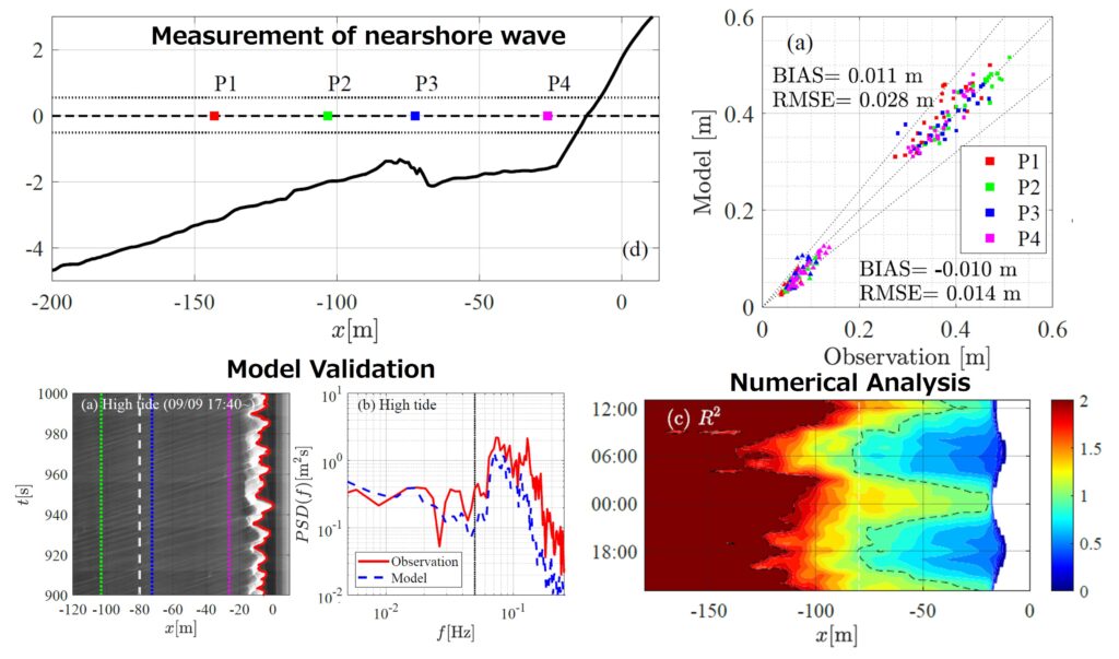
沖で発達する波は、沿岸部へ伝播する間に変形し、砕け、そして残ったエネルギーが遡上波として海浜部に作用します。この複雑なプロセスの中で、沖では存在しなかった周期の極めて長い波(長周期波)が沿岸部で発達し、高波浪時には沿岸災害を増大させる一つの要因となることが知られています。これまで、長周期波の生成・発達や、高波浪の遡上に特に焦点を当て、沿岸部での波浪観測データの分析と、数値モデルによる再現・実験を通じた沿岸での波浪水理の解明と予測技術について研究を行っています。こうした沿岸部での波の水理動態を正しく現象を理解することで、沿岸部での防災対策や海岸地形変化の予測の高度化に貢献することが期待されます。
Waves that develop offshore are deformed and broken as they propagate to the coast, and the remaining energy acts on the beach as wave runup or overtopping. In this complex nearshore process, long waves that do not exist offshore (called infragravity waves) develop in shallow water and are known to be one of the factors that increase coastal disasters during high waves. We have been conducting research on wave hydrodynamics and forecasting techniques in coastal areas by analyzing field measurement data and reproducing them with numerical models, with a particular focus on the generation and development of infragravity waves and high wave runup. It is expected that a correct understanding of the nearshore wave hydrodynamics will contribute to the advancement of disaster prevention and prediction of beach topographic changes.
沿岸災害事例の事後分析
Post-Event Analysis of Coastal Disater
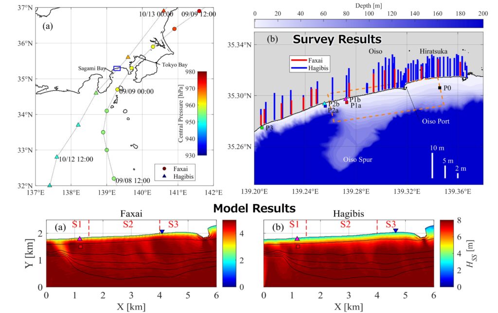
台風による高潮・高波や、大地震による津波などの災害が発生した際には、実際に何が起きていたのかを事後分析により解明することが重要です。被災後の現地調査による被災状況の詳細な把握のほか、波浪観測データや定点監視カメラデータの分析を行ない、さらにそれらを説明しうる数値モデルを用いた再現計算を行うことで、災害時の実際の現象の解明を行っています。こうした丁寧な事後分析を行い、反省を海岸管理に反映させていくことで、将来の同様の災害発生時に生じる被害を緩和することが期待されます。
After disasters such as storm surges and high waves caused by typhoons and tsunamis caused by earthquakes, it is important to clarify what actually happened through post-event analysis. In addition to conducting a detailed post-event survey to understand the damage, we analyze wave observation data and monitoring camera data, and then perform numerical simulations using numerical models that can reproduce the data to clarify the actual phenomena during the disaster. By carefully analyzing the data after the disaster and reflecting our findings in coastal management, we hope to mitigate the damage that would be caused by a similar disaster in the future.
海岸観測手法の開発
Develpment of Coastal Monitoring Method
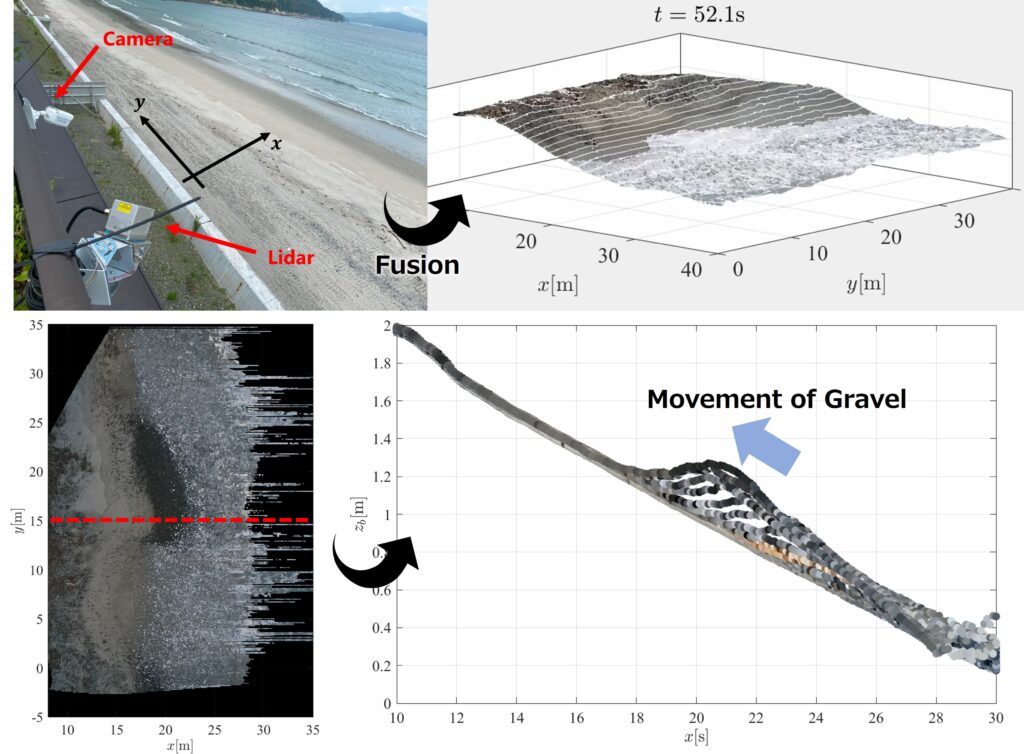
海岸での様々な現象の理解のためには、精緻で詳細な波や地形の観測データの取得が不可欠ですが、広大な領域での高い時空間解像度での観測は従来手法では極めて難しく、新たな観測技術の構築が必要です。これまで様々な観測技術の開発も行ってきました。例えば、LiDARとカメラを同期したシステムを構築することで、波の遡上高と砂と礫それぞれの移動を高い時空間解像度で計測することが可能になりました。こうした技術を活用することで、日々その姿を変える海岸での地形変化がどのように引き起こされているのかの理解につながることが期待されます。
To understand various phenomena on the coast, it is essential to obtain precise and detailed observation data on waves and topographic changes. However, it is difficult to observe a broad area with high spatiotemporal resolution using conventional methods, and new observation techniques need to be developed. We have been developing various observation technologies. For example, by constructing a system that synchronizes a LiDAR scanner and camera, it has become possible to measure wave runup heights and the movement of sand and gravel with high spatiotemporal resolution. The technique is expected to lead to a better understanding of how sand-gravel beaches are shaped.
